


UTALII TANZANIA : On safari in Serengeti’s North: Tanzania is blessed with the world’s Garden of Eden. Serengeti is an approximation of the word used by the Maasai to describe the area, s...
Tuesday, June 28, 2016
Tuesday, June 21, 2016
FAHARI YETU TO PROMOTE TOURISM IN IRINGA

Iringa District is one of the country's sleeping giants that need quick interventions in promoting its tourist attractions.Despite being endowed with historical cultural background and numerous tourist attractions; they are yet to be fully tapped.
According to the 2012 population census, Iringa District had a population of 405,377 consisting mainly of the indigenous Hehe tribe. According to the Bank of Tanzania's 2013 report, Iringa fell behind in contributing to the GDP after Dar es Salaam, Mwanza, Mbeya, Shinyanga. This is despite its potential, and in view of this, a non-governmental organisation Fahari Yetu in collaboration with the European Union under the European Development Fund in Tanzania have embarked on a project to promote cultural heritage and tourism for sustainable development in the Southern Highlands.
 |
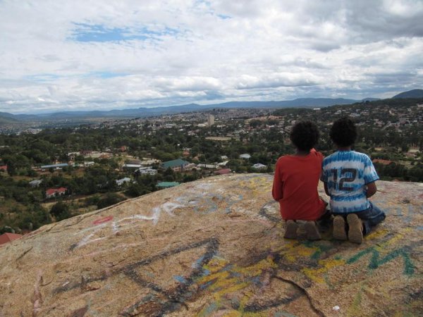
| Isimila Iringa, Photo: Angelo Dutto |
Fahari Yetu assistant project manager Jimson Sanga, who is also a University of Iringa lecturer in tourism and culture, said the Fahari Yetu project was started three years ago with the aim of promoting tourism in the Southern Highlands. "Our first project is Iringa, and we started by educating the people on the importance of preserving culture and identifying tourist attractions and also preserving them from ruin, " he said. He said Fahari Yetu first project includes the restoration of the regional commissioner's office into the district museum that will house the district cultural heritages.
According to him, the building which was built by the Germans in the early 1990s was dilapidated and therefore earmarked for demolition. However after negotiations, the local government agreed to hand it over for restoration and turn it into the districts museum and tourist attraction for both local and international tourists. "We started the renovation about three years ago with mostly planning, but the actual renovation started about a year ago," he said. He explained that so far the renovations total cost was Sh240 million and was expected to be finalized anytime soon before the actual launch, June 25, this year. "We expect the minister for Home Affairs to officiate at the launch of the building, " he said.
He noted that after the launch they will be performing archive activities curation and exhibiting culture and heritage material. Adding that, they will also be identifying and interpreting cultural heritage assets, to preserve and foster cultural awareness as well ad market tourism attractions. He said that they also aim to promote other tourist attractions in the district including Gangilonga, Igeleke Rocks and paintings hanging area including Chief Mkwawa's remains.
In another development Fahari Yetu project manager Mr Jan Kuever said that they museum will not only be a tourist attraction but will also be a cultural educational programme. "Our students lack practical learning experience, but with the museum they will be able to learn practically the history of the past history of the Hehe starting during the colonial era to the death of Chief Mkwawa leading to his successors," he said.
Meanwhile National Museum of Tanzania curator in charge Mr Mawazo Ramadhani said that he has been in the project since it started three years ago. According to him, he is lending expertise from the NMT to ensure the exhibitions go well.
Source: Here
Monday, June 20, 2016
Tuesday, June 14, 2016
Tanzania Travel Tips
 |
| tourists taking a photo of lions on the tree. Photo:tripadvisor |
These are 4 practical things which its a must to know or get knowledge about before you embark on a life time safari experience in Tanzania. Putting them into use will help you to have a great, memorable safari in Tanzania. These are some of the improtant advices Watu Safaris gives to its customers but they do apply to everyone who wants to have a great safari in Tanzania. Enjoy your trip in Tanzania!
1. Your Health Is Vital
Before coming to Tanzania you will have to take few health precautions. Because Tanzania is in the tropical environments which favour growth of different bacteria, flora and fauna that most visitors are accustomed to.
Malaria :
This is the most feared disease to most of the visitors, Aren’t you?. Make sure that before you travel you visit your doctor to get ant-malaria tablets. Also you can buy mosquito sprays. All the accommodation places now days have mosquito nets fixed to your beds and the rooms are sprayed with mosquito repellents too. And just for your information malaria transmitting mosquitos only bites at late nights so its likely that you won't be exposed if all the precautions are taken care of.
Vaccination:
The yellow-fever vaccination is no longer officially required when entering Tanzania, yet because the disease is endemic many doctors will recommend it as a precaution. Other vaccinations that might be considered before you travel include typhoid, hepatitis A and B, meningitis, and tetanus. For more information, contact your doctor.
Food and Water:
While on trip in Tanzania make sure that you drink bottled water, there are many brands available at every retail shop/kiosk. Make sure that if you eat on streets the food is hot, avoid eating salads, juices on streets because its likely that they were not prepared in a hygienic way. Most standard and high end restaurants prepare their food at a required hygienic standards so you shouldn't worry about eating anything there. But be advised that if you are not sure of what you ordered don't eat it. Most places you will eat during your organised safari measures and research have been made by your trip organizer to make sure that the food meets the required standard for you to eat. Mainly each safaris organizer will make sure that both dietary requirements are taken care during your trip.
2. Your Money
The unit of currency is the Tanzanian shilling (TZS) and there are no smaller denominations. Average exchange rate for those coming from UK is TZS 2000/ 1 UK pound and as by November 2010 the exchange rate for a dollar was TZS 1400/ $ 1, please incquire for current rates at the time of your trip.
That said, major currencies (like the USA Dollar, the English Pound, and the Euro) are easily changed in large towns and mainly in bureau de changes. It takes longer to change money in the banks than in the bureau de change. With dollars make sure that you bring new notes not bellow series year 2000. Most places will give low, flat rate for older notes (some place will not buy them). Several banks which includes Standard Chartered Banks, CRDB, National Bank of Commerce (NBC), FMBE, EXIM, Barclays Banks around the country have ATM machines that allow you to withdraw cash from your VISA card and/or MasterCard accounts. Credit cards are accepted only at major lodges, hotels, and travel agents. Travellers checks are not accepted now days in most places even banks and would advice you to carry no or little amount of travellers checks. One Bank which still does traveller's checks is Kenya Commercial Bank (KBC).
While travelling in Tanzania always make sure that your money is secured on your money belt or bag and only have some few notes close by for immediate use if need be. While your safari organizer works hard to make sure that your trip is as safe as possible exposing lots of money on streets or congested areas may attract opportunists, so take care!
3. Visa Information
In Tanzania, visas are required by most foreign nationals whether visiting for a holiday or to conduct business.
Tanzania does permit some foreign nationals (mostly African and Asian) visa free travel for up to three months, however, except for Kenya, Uganda, Burundi and Rwanda, they still need to obtain entry permit clearance.
For more detailed information about Visa please visit the Tanzania Tourist Board visa section.
4. Security During Your Safari
Tanzania is the most peaceful country in East Africa and Africa. While Tanzania police and military forces work hard to make sure that the country is at peace all the time but also the citizens are very friendly and willing to help any time there is problem. Most places have police posts close by and especially all major tourist places. Tanzania Safari organizers works with all peace keepers to make sure that all guests are safe all the time and if any problem arises there is immediate coordination to solve it. Also during your organised trip you will always be accompanied by professional guide who will make sure that you have a safe, enjoyable trip.

This is all for today friends, would love to hear what you think!
5. Culture of local people
Usually you will spend your holiday in Tourist destinations such as Game parks. Around these game parks are villages which local people reside. Example at slopes of Kilimanjaro are Chagga tribe, Ngorongoro conservation area are Masai poeple. So your destination guide will give you briefing on what to do and how to behave when you meet with local people. These helps to create love, trust and harmony with local people.
10 Interesting Facts About Zanzibar
 |
| Zanzibar by the Beach side. Photo: http://cdn1.buuteeq.com/ |
The name Zanzibar is an Arabic word that is translated as 'the coast of black people'. The Zanzibar archipelago is a series of islands on the Indian Ocean about 16-31 miles from the mainland Republic of Tanzania. It is a semi-autonomous region of the Tanzania. The island has the best beaches in the world - and this is not an exaggeration. If you love lazing around in the sun, then this is the place to go. Below are a few facts that will give you an overview of the Island country.
 |
| Zanzibar Coastal View. Photo:http://greatpelicansafaris.com/ |
The name Zanzibar is an Arabic word that is translated as 'the coast of black people'. The Zanzibar archipelago is a series of islands on the Indian Ocean about 16-31 miles from the mainland Republic of Tanzania. It is a semi-autonomous region of the Tanzania. The island has the best beaches in the world - and this is not an exaggeration. If you love lazing around in the sun, then this is the place to go. Below are a few facts that will give you an overview of the Island country.
1. Zanzibar is comprised of several islands, but two are the larger ones. Ugunja is the largest one and is erroneously called Zanzibar. The other is called Pemba.
2. The island is home to the almost extinct Zanzibar Red Columbus Monkey, the Zanzibar Servaline Genet, and the Zanzibar Leopard.
3. Zanzibar has been home to intelligent humans (Homo sapiens) for more than 20,000 years.
4. The capital of Zanzibar is called Zanzibar City and its most historic feature is the ancient Stone Town.
5. Due to its proximity to Equator, Zanzibar is warm throughout the year and has equal day and nights (12-hours each) like most of the East African Countries.
6. Apart from tourism, the other economic activity in Zanzibar is spice growing. In fact, the island is sometimes fondly referred to as The Spice Island due to its cloves, nutmeg, cinnamon, and black pepper.
7. Some ancient potteries have been discovered in Zanzibar showing that it was a major trading route for the ancient Assyrians.
8. Amazingly, the shortest war ever recorded by man is the Anglo-Zanzibar War where the British bombarded the Beit al Hukum Palace and after 38 minutes, a ceasefire was called.
9. Thanks to Monsoon Winds, by the first century, Arabs, Persians and Indians were sailing to Zanzibar in their fast sailing dhows.
10. Throughout history, the Persians, Portuguese, Omani and British have fought to control the important island. It was seen as a gateway to mainland East Africa. In fact, the Sultanate of Omani was the first to trade slaves, cloves and ivory from East African Mainland.
The Island of Zanzibar boasts pristine white sand beaches, abundant sunshine, exotic Swahili dishes, a hospitable people and luxury tourists resorts. If your idea of fun is to mix a jungle safari with lazing on the beach, then you have just found a hidden gem in Zanzibar.
Stay tuned for more fascinating facts about Tanzania.
Source: Here
Thursday, August 20, 2015

Monday, August 17, 2015
The Early Man's Rock Paintings in Kondoa
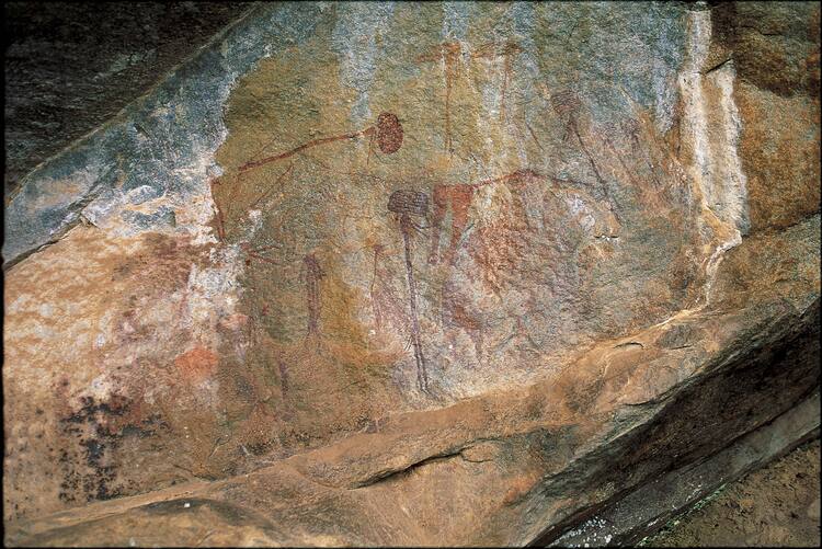
The Kondoa Irangi Rock Paintings are a series of caves carved into the side of a hill looking out over the steppe, approximately nine kilometres east of the main highway from Kondoa to Arusha, about 20 km north of Kondoa, in Tanzania. The caves contain paintings, some of which are believed by the Tanzania Antiquities Department to date back more than 1500 years. The exact number of rock art sites in the Kondoa area is currently uncertain, however estimates are of between 150 and 450 of the decorated rock shelters.[1] The paintings depict elongated people, animals, and hunting scenes. Tourists are asked to report to the Antiquities Department office on the highway at the village of Kolo and ask for the cave paintings guide.
 Dodoma Region © UNESCO
Read more: http://www.lonelyplanet.com/tanzania/kondoa-rock-art-sites#ixzz3inQmHOGV
http://whc.unesco.org/en/list/1183
The spectacular collection of images from over 150 shelters over 2,336 km2 , many with high artistic value, displays sequences that provide a unique testimony to the changing socio-economic base of the area from hunter-gatherer to agro-pastoralist, and the beliefs and ideas associated with the different societies. Some of the shelters are still considered to have ritual associations with the people who live nearby, reflecting their beliefs, rituals and cosmological traditions.
 Dodoma Region © UNESCO
The district of Kondoa, especially around the tiny village of Kolo, lies at the centre of one of the most impressive collections of ancient rock art on the African continent. It's also one of Tanzania's least-known and most underrated attractions. If you can tolerate a bit of rugged travel, this is an intriguing and worthwhile detour.
ntegrity
The boundaries enclose the extent of the main rock art sites. The boundaries do not follow any recognisable feature on the ground, although they are marked with embedded concrete posts.
Most of the rock art sites are stable and relatively well preserved. Although the rock shelters with paintings are located on the slopes of the escarpment or on the plateau and are generally surrounded by a wooded or bushy environment, there are some threats due to village land use practices. In particular, village farming, cattle grazing and harvesting of forestry resources are encroaching on the areas surrounding the rock art sites.
The forested or wooded environment surrounding the rock art sites creates a desirable protective measure for the paintings as this minimizes the effects of the sun, wind and dusts.
The woodland areas around the rock art sites give vital protection to the rock art, and are essential to control soil erosion and retain ground water. Deforestation, through the seeking of building materials and fuel, could seriously damage the images. A large number of sites were illegally excavated before inscription with a loss of contextual material.
One of the key qualities of the Kondoa rock art sites is that they still play an active role in the rituals of local communities. The sites are used for instance for weather-divination, healing and initiation. Whereas it is essential to sustain the links with local communities, there is also a need to ensure that use and conservation do not conflict. For instance in some of the rain-making rituals, animal fat and beer are thrown over the rock art paintings, perhaps a recent adaptation of older practices.
Authenticity
The authenticity of Kondoa rock art is beyond question. It has never been restored or enhanced in any way. What is of special importance about Kondoa is that the rock art exists, largely in its original natural environment, and in the context of a rich living heritage. The places where ancient hunter-gatherers painted rock art perhaps to influence the weather are still used today by local farmer communities in modern rain-making ceremonies. Modern versions of boys’ initiation ceremonies, which a few centuries ago may have led to the creation of certain white paintings, are still held every year in most of the villages in the area. Descendents of the Maa-speaking pastoralists, who once perhaps painted at a number of rock art sites in the area, still visit the area to graze their cattle during periods of drought.
A recent rock painting made by a Sandawe speaking man illustrated a remarkable persistence of artistic tradition, perhaps extending over several millennia.
Protection and management requirements
The Kondoa rock art site was initially managed by the National Monuments preservation ordinance No. 4 of 1937. This was repealed and replaced by the Antiquities Act No 10 of 1964, with its amendment Act No. 22 of 1979. Twelve Kondoa rock painting sites were given a special status and level of protection when they were scheduled as National Monuments in 1949. These sites were re-listed in 1981 when the Government of Tanzania published a new gazette, notice No. 39 published on 27 March 1981 with seven other sites added to the list. The property was declared a Conservation Area in 2004.
A Conservation Plan, started in 2001, was completed and updated in 2005. A Property Management Plan and Statement of Objectives were prepared in 2004. Both of these need to be regularly updated.
The existence of rock paintings in the area was first reported in 1908 and, although a variety of excavations were carried out during the 20th century, the rock art area at Kondoa has never been comprehensively surveyed. The records from these past surveys and work are scattered over a variety of institutions in different countries. At present there is no integrated documentation system for the sites. The management plan notes this as a matter of serious concern and, in order to support the management and monitoring, there is a need for the Department of Antiquities to create a central database of all documentation.
The management of the property will need to create a careful path between supporting the living heritage values of the sites and supporting the physical preservation of the sites. Working together with the Kondoa forest authority, the village governments and communities have now identified areas where trees can be grown for firewood.
Historical Description
The existence of rock paintings in the area was first reported in 1908 by missionaries working near Bukoba. The first published account appeared in 1929 when T.A.M. Nash published an article in the Royal Anthropological Institute Journal. Louis Leakey explored the site in the 1930s and in 1936 put forward an attempt at stylistic classification in his book Stone Age in Africa. The first survey and recording programme was undertaken by H. Fosbrooke in the late 1940s, which resulted in a publication in the Tanganyika Notes and Records Special Publication series. Louis Leakey continued his interest in the site and developed a theoretical scheme of styles, suggesting the art was of great antiquity. Few scholars agreed with these dates and others considered the paintings to be of ethnographic rather than archaeological significance.
Excavations were undertaken by West in 1964 and then by Masao in the late 1970s. More recently Mapunda and Kessy have excavated several sites at Pahi and Baura where remains of Iron Age smelting furnaces, tuiyeres, slag and pottery were recovered.
The site was brought to public attention through the publication of Mary Leakey's book Africa's Vanishing Art: The Rock Paintings of Tanzania in 1983. This was based on tracings of some of the images.
The most recent work has been carried out by Fidelis Masao in 1979 and 1980, and by Emmanuel Anati in 1980 and 1981.
Unfortunately the records of all these interventions are scattered and the information gained from them is not easily accessible. The dossier acknowledges the ‘need for the Department of Antiquities to create a database for all the documentation done so far'. Until that is achieved, any overall assessment of the scope and content of the site is possible. The nomination dossier is not even able to say how many sites or images exist on the site, nor how the images in the nominated area relate to rock art in the neighbouring Singida, Iramba and Lake Eyasi area to the west. A survey and statistical analysis are needed to ascertain the scope of the site and the links with, for instance, the Singida area to the west.
To visit independently, stop at the Antiquities Department office along Kolo’s main road to arrange a permit (per adult/child Tsh27,000/13,000) and mandatory guide (free, but tips expected), some of whom speak English. There’s a good little museum here covering not only archaeology, but also the culture of the Irangi people.
Read more: http://www.lonelyplanet.com/tanzania/kondoa-rock-art-sites#ixzz3inQmHOGV
http://whc.unesco.org/en/list/1183
Serengeti

Serengeti is easily Tanzania’s most famous national park, and it’s also the largest, at 14,763 square kilometres of protected area that borders Kenya’s Masai Mara Game Park. Its far-reaching plains of endless grass, tinged with the twisted shadows of acacia trees, have made it the quintessential image of a wild and untarnished Africa. Its large stone kopjes are home to rich ecosystems, and the sheer magnitude and scale of life that the plains support is staggering. Large prides of lions laze easily in the long grasses, plentiful families of elephants feed on acacia bark and trump to each other across the plains, and giraffes, gazelles, monkeys, eland, and the whole range of African wildlife is in awe-inspiring numbers.

The annual wildebeest migration through the Serengeti and the Masai Mara attract visitors from around the world, who flock to the open plains to witness the largest mass movement of land mammals on the planet. More than a million animals make the seasonal journey to fresh pasture to the north, then the south, after the biannual rains. The sound of their thundering hooves, raising massive clouds of thick red dust, has become one of the legends of the Serengeti plains. The entire ecosystem thrives from the annual migration, from the lions and birds of prey that gorge themselves on the weak and the faltering to the gamut of hungry crocodiles that lie in patient wait at each river crossing for their annual feed.
But it’s not just the wildebeest who use the Serengeti as a migratory pathway. The adjacent reserves of Maswa and Ikorongo, the Ngorongoro Conservation Area, and the Masai Mara Game Reserve in Kenya all allow the animals and birds of the area a free range of movement to follow their seasonal migrations. Indeed, in the wake of the wildebeest migration, many of the less attention-grabbing features of the Serengeti are often overlooked. The park has varied zones in which each ecosystem is subtly different . Seronera in the centre of the park is the most popular and most easily visited area. The Grumeti River in the Western Corridor is the location for the dramatic river crossing during the wildebeest migration. Maswa Game Reserve to the south offers a remote part of the park rewarding in its game-viewing and privacy, and Lobo near the Kenyan border offers a change to see plentiful game during the dry season.
Aside from traditional vehicle bound safaris, hot-air ballooning over the Serengeti plains has become a safari rite-of-passage for travel enthusiasts. The flights depart at dawn over the plains and take passengers close over the awakening herds of wildebeest and zebra, gazelle and giraffe. The extra altitude allows guests to witness the striking stretches of plains punctuated only by kopjes. Up in the sky, you have Africa all to yourself.

Friday, August 14, 2015
The Zaramo
Things You Didn't Know About Their History
HISTORY
Zaramo are an east central Bantu peoples whose ancestors most likely immigrated into modern day Tanzania sometime during the first millennium A.D. Oral histories suggest that the Zaramo moved eastward into their current location from the mountainous Luguru and Kutu areas around the turn of the 18th century. Linguistic evidence supports this history. Trade and slave caravans in the 18th century passed through Zaramo territory on their way to Lake Tanganyika, bringing Islam along with them. As Dar es Salaam, the capital of Tanzania, has grown exponentially in the last twenty years many Zaramo settlements have been incorporated into the city, and many more Zaramo people have immigrated into the city in search of work.


ECONOMY
Most Zaramo cultivation is done by women using a hand-held hoe. They grow maize, millet, and rice near the coast. Tomatoes, potatoes, peppers, casava, cucumbers, and various other vegetables are grown. Tropical fruits, including mango, bananas, and coconut are abundant. In the past fishing and hunting were important, but have largely been replaced by raising domestic animals. Dried fish, brought inland from the coast, are commonly eaten. The Zaramo supply much of the fruit and vegetables that are sold in the markets of Dar es Salaam. Sisal, which is used for making ropes, is grown on large plantations throughout eastern Tanzania. Tanzania is the number one exporter of sisal.
POLITICAL SYSTEMS
 Zaramo did not have centralized political systems. Their social organization was based on small-scale matrilineal kin groups which were self governing. Lineage heads were chosen by community leaders. These leaders held the land rights of the lineage. Occasionally a powerful leader emerged in the area who had greater influence. Land ownership was determined by the original members who inhabited it. The leader was responsible for distributing the land and maintaining lineage rituals. Most of the leaders in Zaramo communities were men, but on occasion they could be women. They settled disputes between family members, and were often attributed with spiritual powers, such as the ability to make rain, or to communicate with the spirit world. Despite colonial reports indicating a lack of political unity in the area, Zaramo peoples were able to assemble between four and five thousand people to march on Bagamoyo in 1875 in protest of the Sultan failing to pay tribute.
RELIGION
 Most Zaramo believed in a supreme God, Mulungu, who was associated with rainfall. Most prayers were directed to familial spirits. Religion among the Zaramo was a household affair. Every family was responsible for appeasing its ancestral spirits. Shrines were built to the spirits on the ancestral homeland, and members of the family were expected to journey to these sites to make the proper offerings. Zaramo believed that major disasters and illnesses were sent by Mulungu, but appeals and prayers must be made to the ancestral spirits who served as a liason between living men and God. In order to determine the proper course of action necessary to appease an offended spirit, a spirit medium, or mganga would be consulted. Through various divination techniques, the mganga would communicate with the spirits and then prescribe treatment for an illness or social imbalance.
Wednesday, August 12, 2015
Zanzibar

Portuguese invasion and control of the Swahili Coast in the late 16th century ended the golden age of the archipelago, although the Omani Arabs returned to power less than a century later. Today, many of the winding streets and high townhouses of old Stone Town remain unchanged and visitors can walk between the sultan’s palace, the House of Wonders, the Portuguese fort and gardens, the merchants’ houses, and the Turkish baths of the old city. Day-long spice tours to working plantations offer visitors the chance to observe the cultivation of cloves, vanilla, nutmeg, cinnamon, and other spices that have made the island famous.
Zanzibar’s coastline offers some of the best beaches in the world, but sand and surf vary depending on what side of the island you’re on. On the east coast, waves break over coral reefs and sand bars offshore, and low tide reveals small pools of starfish, small minnows, and anemones. Up north, ocean swimming is much less susceptible to the tides, and smooth beaches and white sand make for dazzling days in the sun.

That said, the Chole Island Marine Park just off Stone Town – and nearby Prison, Grave, and Snake Islands – make a refreshing day-trip and a good break from exploring the winding passageways of the old city.

On the south coast of Zanzibar lies the Menai Bay Conservation Area, a sea turtle protection area for the endangered species that come to breed on the island. Roads to the southeast coast take visitors through the Jozani Forest, home to Zanzibar’s rare Red Colobus monkeys and a number of other primate and small antelope species.

Tuesday, August 11, 2015
Mount Kilimanjaro

Above the gently rolling hills and plateaux of northern Tanzania rises the snowy peak of Mt. Kilimanjaro, it’s slopes and glaciers shimmering above the rising clouds. Kilimanjaro is located near the town of Moshi and is a protected area, carefully regulated for climbers to enjoy without leaving a trace of their presence. The mountain’s ecosystems are as strikingly beautiful as they are varied and diverse. On the lowland slopes, much of the mountain is farmland, with coffee, banana, cassava, and maize crops grown for subsistence and cash sale. A few larger coffee farms still exist on the lower slopes, but much of the area outside the national park has been subdivided into small plots. Once inside the park, thick lowland forest covers the lower altitudes and breaks into alpine meadows once the air begins to thin. Near the peak, the landscape is harsh and barren, with rocks and ice the predominant features above a breathtaking African view.

Climbing Mt. Kilimanjaro is the highlight of most visitors’ experiences in Tanzania. Few mountains can claim the grandeur, the breathtaking views of Amboseli National Park in Kenya, the Rift Valley, and the Masaai Steppe, that belongs to Kilimanjaro. Hiking on the ‘rooftop of Africa’ — the highest point on the continent at 5896 metres — is the adventure of a lifetime, especially because, if paced well, everyone from seasoned trekkers to first-time enthusiasts can scale the snowy peak. For more information, see the ‘Mountain Climbing‘ section under ‘Things to Do.
Kilimanjaro. The name itself is a mystery wreathed in clouds. It might mean Mountain of Light, Mountain of Greatness or Mountain of Caravans. Or it might not. The local people, the Wachagga, don’t even have a name for the whole massif, only Kipoo (now known as Kibo) for the familiar snowy peak that stands imperious, overseer of the continent, the summit of Africa.
Kilimanjaro, by any name, is a metaphor for the compelling beauty of East Africa. When you see it, you understand why. Not only is this the highest peak on the African continent; it is also the tallest free-standing mountain in the world, rising in breathtaking isolation from the surrounding coastal scrubland – elevation around 900 metres – to an imperious 5,895 metres (19,336 feet).
Kilimanjaro is one of the world’s most accessible high summits, a beacon for visitors from around the world. Most climbers reach the crater rim with little more than a walking stick, proper clothing and determination. And those who reach Uhuru Point, the actual summit, or Gillman’s Point on the lip of the crater, will have earned their climbing certificates.
And their memories.
And their memories.
But there is so much more to Kili than her summit. The ascent of the slopes is a virtual climatic world tour, from the tropics to the Arctic.
Even before you cross the national park boundary (at the 2,700m contour), the cultivated footslopes give way to lush montane forest, inhabited by elusive elephant, leopard, buffalo, the endangered Abbot’s duiker, and other small antelope and primates. Higher still lies the moorland zone, where a cover of giant heather is studded with otherworldly giant lobelias.
Even before you cross the national park boundary (at the 2,700m contour), the cultivated footslopes give way to lush montane forest, inhabited by elusive elephant, leopard, buffalo, the endangered Abbot’s duiker, and other small antelope and primates. Higher still lies the moorland zone, where a cover of giant heather is studded with otherworldly giant lobelias.
Above 4,000m, a surreal alpine desert supports little life other than a few hardy mosses and lichen. Then, finally, the last vestigial vegetation gives way to a winter wonderland of ice and snow – and the magnificent beauty of the roof of the continent.
About Kilimanjaro National Park
Size: 1668 sq km 641 sq miles).
Location: Northern Tanzania, near the town of Moshi.
Size: 1668 sq km 641 sq miles).
Location: Northern Tanzania, near the town of Moshi.
Getting there
128 km (80 miles) from Arusha.
About one hour’s drive from Kilimanjaro airport.
128 km (80 miles) from Arusha.
About one hour’s drive from Kilimanjaro airport.
What to do
Six usual trekking routes to the summit and other more-demanding mountaineering routes.
Day or overnight hikes on the Shira plateau. Nature trails on the lower reaches.
Trout fishing.
Visit the beautiful Chala crater lake on the mountain’s southeastern slopes.
Six usual trekking routes to the summit and other more-demanding mountaineering routes.
Day or overnight hikes on the Shira plateau. Nature trails on the lower reaches.
Trout fishing.
Visit the beautiful Chala crater lake on the mountain’s southeastern slopes.
When to go
Clearest and warmest conditions from December to February, but also dry (and colder) from July-September.
Clearest and warmest conditions from December to February, but also dry (and colder) from July-September.
Accommodation
Huts and campsites on the mountain.
Several hotels and campsites outside the park in the village of Marangu and town of Moshi.
Huts and campsites on the mountain.
Several hotels and campsites outside the park in the village of Marangu and town of Moshi.
NOTE:
Climb slowly to increase your acclimatisation time and maximise your chances of reaching the summit.
To avoid altitude sickness, allow a minimum of five nights, preferably even more for the climb. Take your time and enjoy the beauty of the mountain.
Climb slowly to increase your acclimatisation time and maximise your chances of reaching the summit.
To avoid altitude sickness, allow a minimum of five nights, preferably even more for the climb. Take your time and enjoy the beauty of the mountain.
NOTE 2:
NEW RATES FOR PORTERS AND GUIDES
(JUNE ’08)
NEW RATES FOR PORTERS AND GUIDES
(JUNE ’08)
Porters
USD 10 per day
CooksUSD 15 per day
GuidesUSD 20 per day
USD 10 per day
CooksUSD 15 per day
GuidesUSD 20 per day
Tuesday, August 4, 2015
Ol Donyo Lengai
 Overlooking Lake Natron and the bushland of Kenya to the north, Ol Donyo Lengai, which means ‘the home of God’ in Maasai, is an active volcano and one of Tanzania’s most spectacular and undiscovered climbs. The volcano erupts sporadically, sending small streams of grey lava down the crater rim and spitting hot ash high into the air. The climbs which are highly challenging are undertaken overnight so that hikers can experience sunrise over the Rift Valley escarpment.

Welcome to the Swahili International Tourism Expo (S!TE)
1 – 3 October 2015 Mlimani City Conference Complex, Dar-es-Salaam Admission is reserved for delegates over 16 years of age
Want to Know more about S!TE 2015? Watch this video by Terry Dale
S!TE 2014 Photo Gallery
FASTJET EXTENDS SUPPORT TO TTB’S S!TE 2015
The Fastjet Airline has announced to support the Swahili International Tourism Expo(S!TE) scheduled to take place from October 1st to 3rd this year at Mlimani city Conference Center in Dar es salaam.
The fastjet pledge was made today when the officials from the airline met with Tanzania Tourist Board’s (TTB) Managing Director Ms Devota Mdachi for a short meets with Fastjet officials to finalize discussions on how the company can support the second edition of the fast growing Expo organized by TTB in collaboration with the South African based Company namely Pure Grit.

As per support agreement, The Fastjet Airline will offer free air tickets for the S!TE hosted buyers’ pre and post fam trip to and from tourist attractions within destination Tanzania. Hosted buyers and international journalists coming for S!TE from overseas will have an opportunity to visit and see some of our tourism products in National Parks, Game Reserves, Historical site and Cultural tourism modules. The Fastjet Airline which operates as a local airline in Tanzania has decided to chip in S!TE 2015 as part of Public Private partnership in promoting the country. The s TTB’Acting Managing MSs Devota Mdachi congratulated the The Fastjet Airline move, and invited many other stakeholders to come on board as this year event so that to make the S!TE 2015 a success.

As per support agreement, The Fastjet Airline will offer free air tickets for the S!TE hosted buyers’ pre and post fam trip to and from tourist attractions within destination Tanzania. Hosted buyers and international journalists coming for S!TE from overseas will have an opportunity to visit and see some of our tourism products in National Parks, Game Reserves, Historical site and Cultural tourism modules. The Fastjet Airline which operates as a local airline in Tanzania has decided to chip in S!TE 2015 as part of Public Private partnership in promoting the country. The s TTB’Acting Managing MSs Devota Mdachi congratulated the The Fastjet Airline move, and invited many other stakeholders to come on board as this year event so that to make the S!TE 2015 a success.
Subscribe to:
Posts (Atom)


